
-
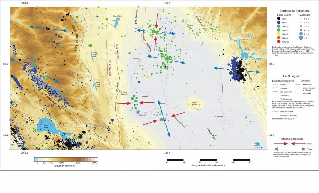 Earthquakes in the West Sacramento Valley, California
 -
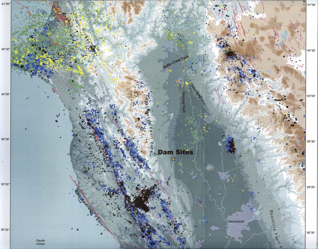 Earthquakes in Northern California from 1970 to 2000.
 -
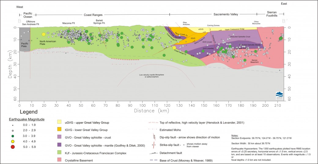 Seismicity Section through the Proposed Newville Damsite
 -
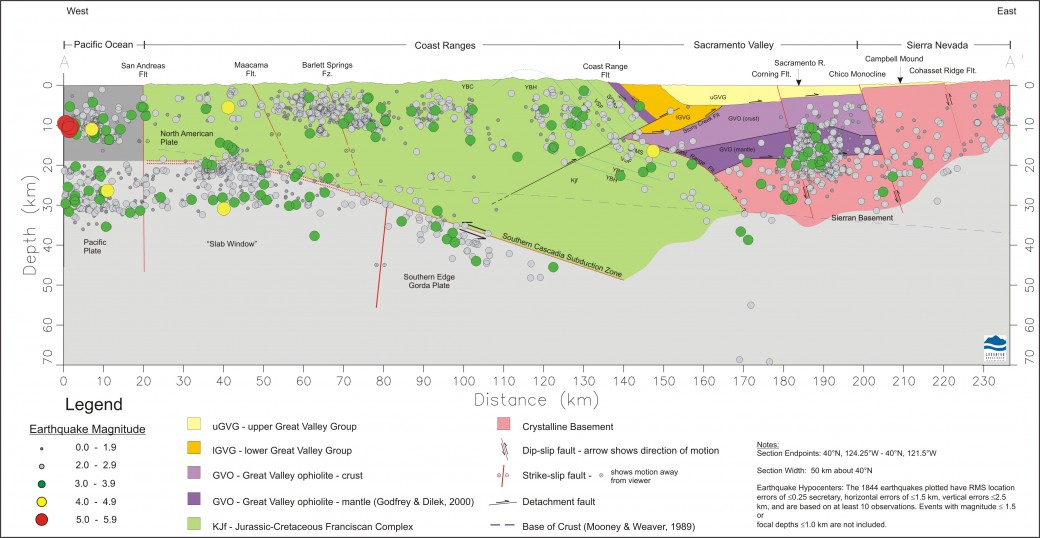 Seismicity Section along 40°N in Northwestern California
Project Overview
Lahontan GeoScience conducted a seismotectonic evaluation of the northeastern California Coast Ranges and the northwestern Sacramento Valley (California) to identify potential seismic sources capable of generating significant ground motion at several proposed dam sites. LGS was part of a team led by William Lettis and Associates that conducted a seismic hazard analysis for the California Department of Water Resources (DWR).
Tectonic Setting
Earthquake activity in the northern Coast Ranges is directly related to interactions between the Pacific, Juan de Fuca and North American plates. Transpressional motion between the Pacific Plate and the Sierra Nevada microplate (situated between the Pacific and North American plates) is accommodated across a 100 km -wide northwest-trending zone of distributed shear that extends from San Francisco Bay to the vicinity of the Mendocino Triple Junction near Cape Mendocino. The major strike-slip faults of this zone are the San Andreas fault, which ruptured along the coast in 1906; the Maacama, Healdsburg, and Rodgers Creek fault zones to the east of the San Andreas fault; and further east, the Bartlett Springs and Green Valley fault zones. Crustal shortening is accommodated by structures in the Coast Range-Sierran Block boundary zone (e.g., segments of the blind Great Valley thrust fault). Relative convergent motion between the Gorda plate, a structural element of the larger Juan de Fuca plate, and the Sierra Nevada microplate is accommodated along the Cascadia subduction zone, which extends from the Mendocino Fracture Zone north to British Columbia. At the latitude of the Mendocino transform the Gorda plate is undergoing internal deformation as it is subducting into the mantle. Much of the seismicity in the vicinity of Cape Mendocino is related to shallow deformation in the overlying Sierran microplate.
The proposed DWR dam sites lie along the western edge of the Sacramento Valley in a tectonic zone referred to as the Coast Ranges-Sierran Block (CRSB) boundary zone. The CRSB boundary zone is an active fold and thrust belt between the high-angle, northwest-striking dextral faults of the Coast Ranges and the Sierran Block. It is underlain by the Great Valley fault, a system of blind, segmented thrust faults. Evidence for seismic activity of blind thrust faults in the southern CRSB boundary zone includes the occurrence of the 1982 ML 5.4 New Idria, the 1983 ML 6.7 Coalinga, and the 1985 ML 5.5 North Kettleman Hills earthquakes in the western San Joaquin Valley. The historic 1889 ML 6 Antioch earthquake and the 1892 ML 6+ Winters-Vacaville sequence provide evidence of the seismogenic potential of the northern CRSB boundary zone in the southwestern Sacramento Valley.
Earthquake Activity
Figure 1 shows the distribution of well-located earthquakes in the region from 1970-2000 and is similar to that of the historical earthquakes. The most prominent zones of seismic activity are in the northern Coast Ranges, and are associated with faults of the San Andreas fault system and active subduction of the Gorda plate beneath the North American plate. East of the Sacramento Valley, there is a low to moderately active zone of seismicity that coincides with the Walker Lane Belt as it extends northwest from the Lake Tahoe region to Lassen Peak; this seismogenic zone has been referred to in the literature as the Sierra Nevada – Great Basin boundary zone (Van Wormer and Ryall, 1980). In the Sacramento Valley, seismic activity occurs at a relatively low level and tends to be associated in clusters. Some of these clusters are isolated such as in the vicinity of Lake Oroville (related to the 1975 ML 5.7 Oroville earthquake), in the vicinity of Williams (the Maxwell and Colusa swarms) and near the town of Madison (site of a M 4.2 event in 1978). Other clusters are more diffusely distributed such as the activity in the Willows area and the zone of seismicity extending from Red Bluff to Redding. As can be seen in Figure 1, the earthquakes in the Sacramento Valley are located significantly deeper than events in the northern Coast Ranges to the west and the Sierra Nevada to the east.
Seismogenic Deformation in the Sacramento Valley
Earthquake focal mechanisms calculated from seismic events occurring between 1970 and 2000 were used to characterize the regional stress field, the orientation of which helps to determine which of the many faults in the region may be favorably oriented to rupture in the future. The local orientation of the maximum and minimum principal stresses are assumed to be parallel to the seismic P- and T-axes, respectively, derived from the focal mechanisms. This permits a comparison of tectonic styles in the region and also provides a framework for assessing the potential for seismogenic reactivation of pre-existing structures.
The method of Twiss et al. (1993) was used to evaluate incremental strain accommodated by earthquakes within the clusters shown in the figure. The analysis consists of inverting seismic P and T axes from groups of focal mechanisms for a best-fit incremental strain tensor that characterizes the average deformation of the volume of crust in which the earthquakes are located.
Seismogenic deformation in the Sacramento Valley domains east of the proposed dam sites (near Colusa, Maxwell and Willows) is characterized by crustal shearing with varying components of vertical deformation. The seismicity is associated with right-oblique slip on blind, north- to northwest-striking faults. Dextral strike-slip faulting in these regions is consistent with accommodation of distributed right-lateral shear east of the Pacific Plate. Overall deformation is characterized by “transpression” with varying components of net crustal thickening. These results indicate that seismogenic deformation accommodates a component of NE-directed shortening, which is consistent with geologic evidence for late Cenozoic activity of segments of the blind Great Valley thrust fault in the west-central and northwestern Sacramento Valley. The role that this seismic hazard analysis plays in the site selection process for the proposed dams is to identify fault orientations that may be active in the current tectonic stress field, even though these faults may not exhibit activity at the present time.

- New Research on Northern California TectonicsJames Humphrey of LGS and Jeff Unruh of LCI have published a new paper on the tectonics driving defo...
 We’ve Moved!Lahontan GeoScience Has Moved! LGS has moved its office to a new location in south Reno....