
-
Mono Basin earthquakes
Figure 1. Earthquakes in the Mono Basin region , 1970-2010, from the NCEDC catalog.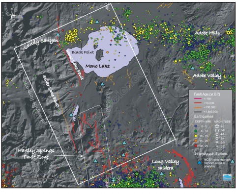
Figure 1. Earthquakes in the Mono Basin region , 1970-2010, from the NCEDC catalog.
-
Mono Basin Earthquake Focal Mechanisms
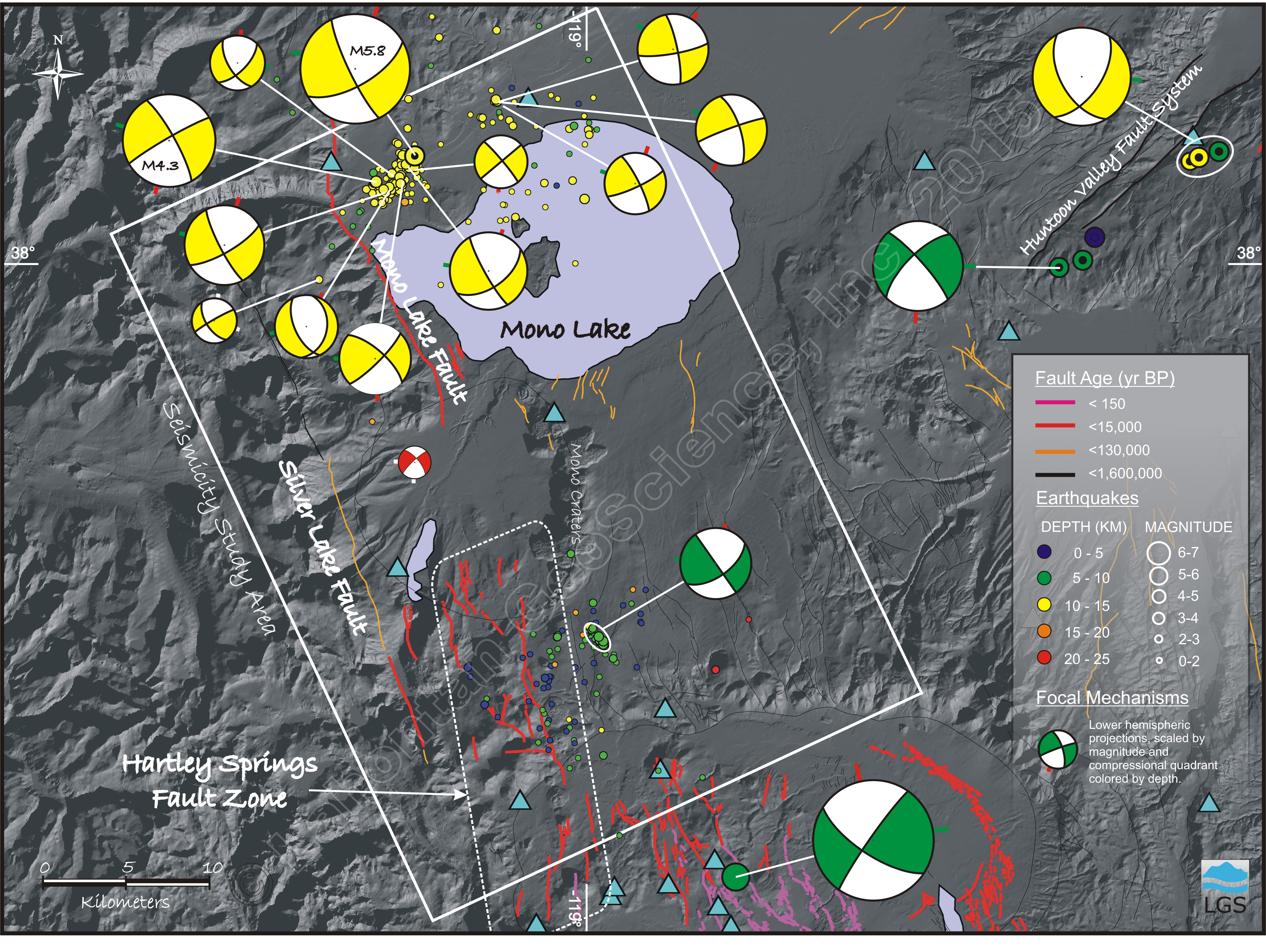
Figure 2. Focal mechanisms (colored circles) were calculated using first motion polarities from relocated earthquakes in the seismicity study area. The beachball diagrams are lower hemispheric projections with the compressional quadrant shaded a color that corresponds to the depth (see Legend). The stubs on the beachballs show the orientation of the P (red) and T (green) axes. Strike slip and normal-oblique slip mechanisms predominate in this dataset. The three mechanisms outside the study area were calculated using NCEDC data from M5 and greater earthquakes. The blue triangles show the location of some of the NCSN seismograph stations used in the inversions.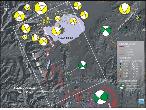
Figure 2. Focal mechanisms (colored circles) were calculated using first motion polarities from relocated earthquakes in the seismicity study area. The beachball diagrams are lower hemispheric projections with the compressional quadrant shaded a color that corresponds to the depth (see Legend). The stubs on the beachballs show the orientation of the P (red) and T (green) axes. Strike slip and normal-oblique slip mechanisms predominate in this dataset. The three mechanisms outside the study area were calculated using NCEDC data from M5 and greater earthquakes. The blue triangles show the location of some of the NCSN seismograph stations used in the inversions.
-
Seismicity Section through 1990 M5 Lee Vining Earthquake
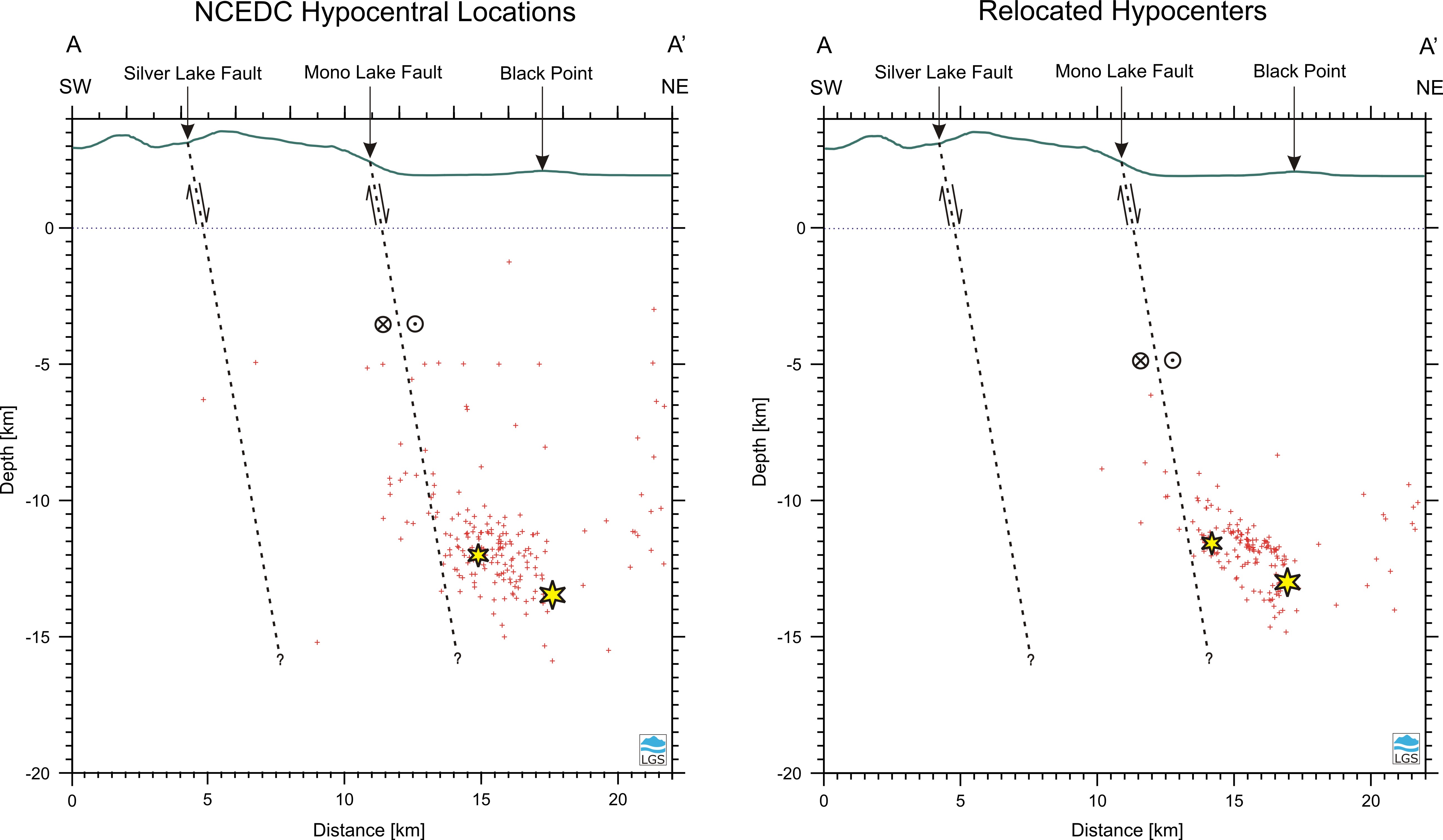
Figure 3. Southwest-northeast cross section through the northern part of the seismicity study area. The left panel shows the distribution of hypocenters (red crosses) from the NCEDC catalog. Only events that were recorded on at least 8 NCSN stations are shown. The right panel shows the hypocenters relocated for this study. The yellow stars show the location of the 24 October 1990 M5.8 mainshock and the largest aftershock (5 November 1990 M4.3). Arrows indicate the relative vertical motion on the faults. Circles show relative horizontal motion with the cross indicating motion away from viewer and the point indicating motion towards. The Silver Lake fault and Mono Lake faults are projected to depth with an 80 degree east dip. Black Point is a basaltic volcanic cone that erupted about 13,600 yr BP under a highstand of Mono Lake (Benson et al., 2003).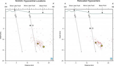
Figure 3. Southwest-northeast cross section through the northern part of the seismicity study area. The left panel shows the distribution of hypocenters (red crosses) from the NCEDC catalog. Only events that were recorded on at least 8 NCSN stations are shown. The right panel shows the hypocenters relocated for this study. The yellow stars show the location of the 24 October 1990 M5.8 mainshock and the largest aftershock (5 November 1990 M4.3). Arrows indicate the relative vertical motion on the faults. Circles show relative horizontal motion with the cross indicating motion away from viewer and the point indicating motion towards. The Silver Lake fault and Mono Lake faults are projected to depth with an 80 degree east dip. Black Point is a basaltic volcanic cone that erupted about 13,600 yr BP under a highstand of Mono Lake (Benson et al., 2003).
-
Seismotectonic analysis of the Mono Basin Region, eastern California
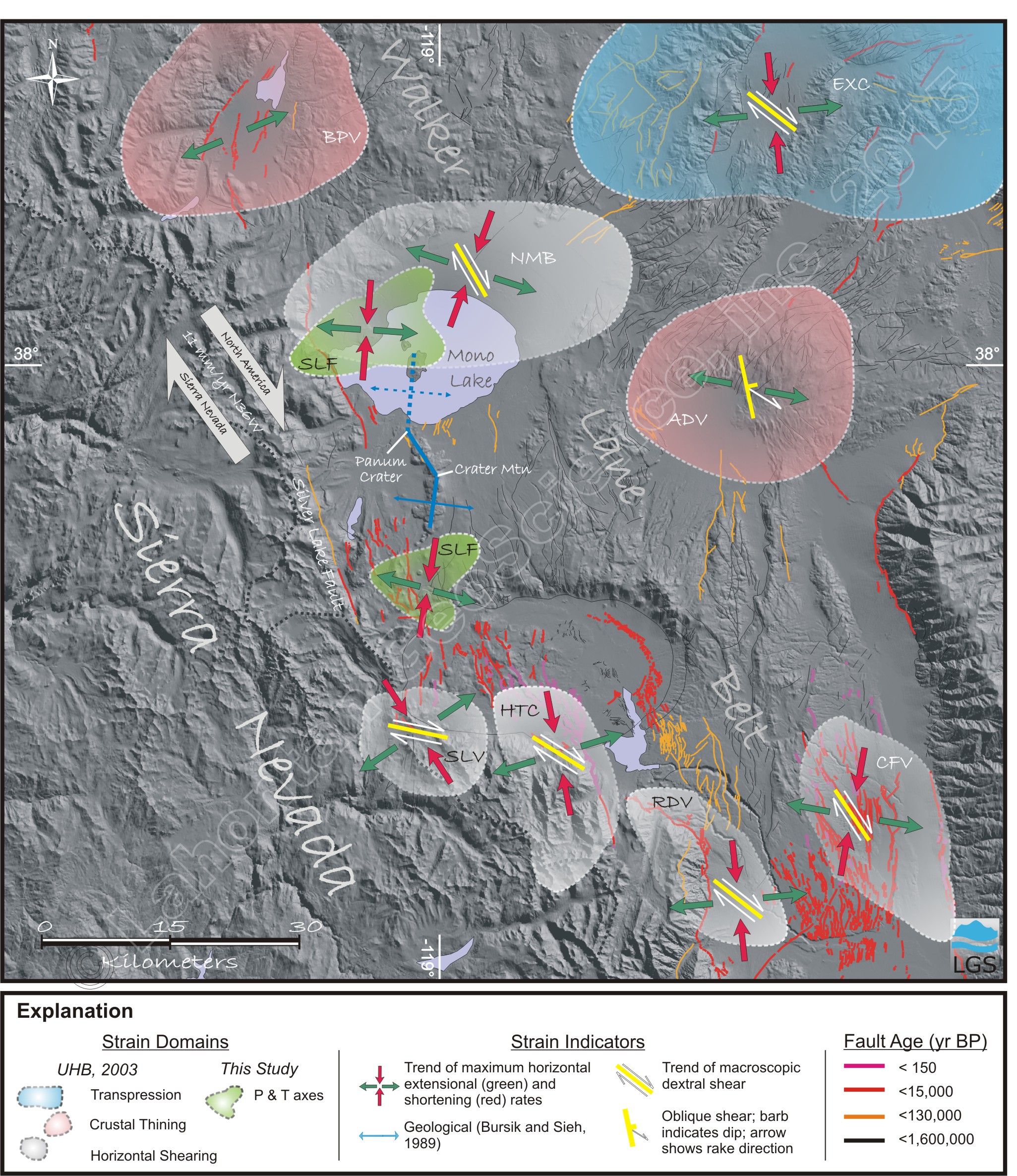
Figure 4. Seismotectonic setting for the Mono Basin region. The strain domains are transpressional (blue), crustal thinning (pink) and horizontal shearing (grey). Horizontal P and T axes calculated in this study are complied from relocated earthquakes in the light green areas (SLF - this study).
Figure 4. Seismotectonic setting for the Mono Basin region. The strain domains are transpressional (blue), crustal thinning (pink) and horizontal shearing (grey). Horizontal P and T axes calculated in this study are complied from relocated earthquakes in the light green areas (SLF - this study).
Project Overview
A seismotectonic analysis of the Mono Basin region was conducted by LGS to support the seismic hazard assessment of several dams in the eastern Sierra Nevada, California. Earlier studies suggested that the Silver Lake fault may be the controlling earthquake source in deterministic seismic hazard analyses for seven dams in the eastern Sierra Nevada. The overall purpose of the project was to provide develop a refined seismotectonic analysis for the Silver Lake, Hartley Springs and Mono Lake faults. The seismotectonic analysis characterizes the orientation of the current strain field and identifies those fault systems that are favorably situated to accommodate the strain. This study was performed for AMEC Geomatrix, Inc. in 2011.
Tectonic Setting
Fault activity along the Sierra Nevada range front should be viewed within the context of the large-scale shearing that takes place between the Sierran block and the Great Basin to accommodate the relative motion of the Pacific and North America plates. This zone of predominately dextral shearing is known as the Walker Lane belt (Wright, 1976; Stewart, 1988), which extends 700 km from the southern Cascades to the Mojave Desert. Approximately 15 to 20 percent of Pacific-North American plate motion is transferred from the San Andreas fault zone in southern California east to the Walker Lane belt (Sauber et al., 1994; Bennett et al., 1997). The pattern of active strike-slip and normal faulting in the Walker Lane belt along the eastern boundary of the Sierran block primarily accommodates northwest translation of the block relative to North America. Unruh, Humphrey and Barron (2003) developed a kinematic model that describes the overall style of deformation as transtensional, i.e. horizontal shearing and oblique crustal thinning.
Also active in this environment are northeast-striking sinistral strike-slip faults that are conjugate to the northwest faults and act to transfer some strain from the west side of the Walker Lane belt to the east. In the central Walker Lane belt, at the latitude of the Silver Lake fault, one such system exists that extends northeast from the Mono Basin to the Gabbs Valley Range in Nevada. This system, also referred to as the Mina Deflection (Wetterauer, 1977), transfers a portion of the dextral slip from the Owens Valley fault zone to the south through northeast- and east- striking sinistral faults to northwest-striking dextral faults bounding the Gabbs Valley Range (Wesnousky, 2005).
Technical Approach
A catalog of earthquakes was obtained for this project from the Northern California Seismic Network operated by the USGS and archived by the Northern California Earthquake Data Center (NCEDC) at the Berkeley Seismological Laboratory (Figure 1). This catalog contains records of instrumentally-recorded earthquakes located in a region extending from latitude 36.5°N to 39°N and longitude 120°W to 116.5°W for the time period 1969 – 2010. The magnitude of the earthquakes ranges from 0 to 6.4. These earthquakes were relocated using the double-difference algorithm of Waldhauser and Ellsworth (2000). This approach takes advantage of the fact that, if the hypocentral separation between two earthquakes is small compared to the event-station distance and the scale length of velocity heterogeneity, then the ray paths between the source region and a common station are similar along almost the entire ray path. The difference in travel times for two closely-spaced events observed at one station can be attributed with high accuracy to the spatial offset between the events. Therefore, pairs of closely-spaced events can be located very precisely and linear trends in diffuse clustering of seismicity (presumably related to slip on a single fault) can be highlighted. Single event focal mechanisms for the earthquakes relocated in this study were calculated using the phase polarities from the NCEDC catalog and the hypocentral locations and take-off angles from the double-difference solutions (Figure 2). The P and T axes from the focal mechanisms were used to characterize the orientation of the strain field.
Seismicity in the Vicinity of the Mono Lake Fault
The cluster of earthquakes located on the north shore of Mono Lake has been relocated to provide a more precise view of the pattern of deformation east of the range front (Figure 1). This distribution of seismicity is dominated by the 1990 ML5.8 Lee Vining sequence, which is located between the Mono Lake fault and Black Point, a 13,600 yr BP volcanic cone on the north shore of Mono Lake (Benson et al., 2003). To the east of Black Point the relocated epicenters are more diffusely distributed. The NCEDC locations (Figure 1) show an ellipsoidal cloud of seismicity with the long axis trending northeast. Section A-A’ is a vertical northeast-oriented cross section through these epicenters (Figure 3 left panel). The focal depths range from 5 to 15 km, close to the base of the seismogenic zone for quartz-rich rocks (e.g. granite). The relocated earthquakes show a more compact pattern of seismicity that dips distinctly to the east between the Mono Lake fault and Black Point (Figure 2; right panel in Figure 3). In Figure 3, the Silver Lake and Mono Lake faults are projected to depth with 80° east dips based on the steeply dipping nodal planes determined in the focal mechanism calculations (Figure 2). This interpretation suggests that the Lee Vining sequence is located in the hanging wall of the Mono Lake fault.
Seismotectonic Analysis
Figure 4 (above) summarizes the results of this seismotectonic analysis. The trends of horizontal strain rate axes from Unruh, Humphrey and Barron (UHB, 2003) are plotted in the domains from which the focal mechanisms were analyzed. The strain domains are transpressional (blue), crustal thinning (pink) and horizontal shearing (grey) and identified with three letter abbreviations: ADV – Adobe Valley, BPV – Bridgeport Valley, CFV – Chalfant Valley, EXC – Excelsior Mountains, HTC – Hilton Creek fault, NMB – Northern Mono Basin, RDV – Round Valley, SLV – Southern Long Valley. Horizontal P and T axes calculated in this study are compiled from relocated earthquakes in the light green areas (SLF). Yellow bars indicate the trend of macroscopic shear (UHB, 2003). Light blue arrows show the direction of extension inferred from the Mono Craters (Bursik and Sieh, 1989). Grey arrows show the N36W direction of Sierran microplate translation relative to North America (Argus and Gordon, 1991). Faults in the figure are from the Quaternary Fold and Fault Database (USGS, 2006). Digital topography is taken from the 1/3 arc second National Elevation Dataset.
In summary, the Silver Lake fault is situated in a regional transtensional environment driven by the northwest translation of the Sierra Nevada relative to stable North America. This translation is accommodated by horizontal dextral shearing along faults oriented subparallel to the small circles around the Euler pole of the Sierran block. Faults oblique to this northwest trend have increasingly larger components of vertical deformation, resulting in localized areas of crustal thinning. Despite its northwest strike there is little seismicity associated with the Silver Lake fault. Small to moderate earthquakes generally occur east of the Silver Lake fault along the eastern side of the Hartley Springs fault zone in the south and to the east of the Mono Lake fault in the north. Seismogenic deformation in these areas is generally occurring as horizontal dextral shearing on northwest-striking planes. There is an area of seismic quiescence between these two areas that is occupied by north striking dike intrusions (Mono Craters and the volcanic centers in Mono Lake). It has been hypothesized elsewhere that the intrusion of dikes underlying the Mono Craters has relieved the east-west extensional strain component acting on the Silver Lake fault. The absence of deformation of paleoshorelines of Lake Russell and glacial moraines at Bloody Canyon (described in the main report) support this hypothesis. It is possible that the north-striking fractures controlling the alignment of the Mono Craters have shifted the locus of deformation east of the range front faults and that thermally weakened crust over a larger area in the Mono Basin region is accommodating the regional dextral shear in an aseismic manner.

- New Research on Northern California TectonicsJames Humphrey of LGS and Jeff Unruh of LCI have published a new paper on the tectonics driving defo...
 We’ve Moved!Lahontan GeoScience Has Moved! LGS has moved its office to a new location in south Reno....